Things To Do
Jackson County
Jackson County is where the venue is... all local attractions
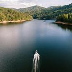
Signal Ridge Marina
Bait and tackle for fishing. Lake maps to find waterfalls. Boat rentals. 3 waterfalls and parks to stop along the 26 miles of shoreline at 3,494' in elevation. Lake Glenville is the HIGHEST major lake east of the Mississippi.
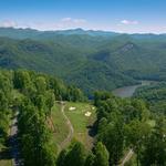
Nicklaus Design Golf- Bear Lake Reserve
Experience unrivaled mountaintop golf from the world’s first 9-hole Nicklaus Design® course. This strategically designed masterpiece at the summit features incredible views of the Blue Ridge Mountains in all directions and two of the toughest par 4 holes you’ll ever play. Sitting at 1,300 feet above Bear Creek Lake, our Golf Club also features a well-equipped Pro Shop, putting green, and driving range.
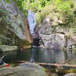
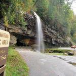
Paradise Falls- (Extreme Hike)
8.6 Miles from Running Cedar Springs- 15 Minute Drive BEST HIDDEN GEM BUT HARD! Climb down the mountain using ropes tied to trees, puddle jump through running creek rocks and then the beautiful Paradise waterfall with swimming holes on the top of the falls and bottom. Watch cliff jumpers or be a cliff jumper yourself. Pack a cooler with drinks and snacks to swim for the day.
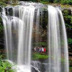
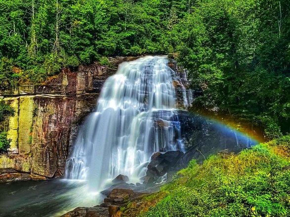
Dry Falls
30 Miles from Running Cedar Springs- 45 Minute drive Dry Falls, a popular waterfall located a few miles outside of Highlands, gives you the rare treat of walking safely behind a waterfall. This 75-ft. tall waterfall in the Nantahala National Forest flows over a cliff, allowing you to walk behind the falls and stay dry (hence the name). During rainy spells when the water volume is higher, the spray will prevent you from staying totally dry. ***ONE OF VANESSA'S FAVORITES***
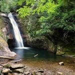
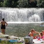
Courthouse Falls
17 Miles from Running Cedar Springs- 40 minute drive 45' narrow chute into a deep pool perfect for a swim on a hot day! 7/10 of a mile hike which is Easy. Trailhead is 3 miles up a gravel road.
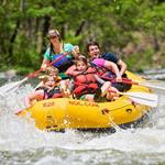
Tuckaseegee Outfitters
Family Friendly Whitewater Rafting in the Great Smoky Mountains!

Scotts Creek Tubing at Willets Depot & Campground
Ride the RIPPLES! Experience the thrill of family friendly tubing down local creek rapids!
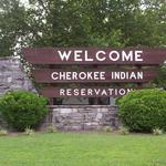
Cherokee, NC
33 Miles from Running Cedar Springs- 45 Minute Drive Visit the Indian Reservation and town of Cherokee, NC. The town has shopping, food, activities, and an Indian Tourist trap...but has ice cream!

Harrah's Cherokee Casino Resort
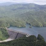
Fontana Dam
65 Miles from Running Cedar Springs- 1 hour and 20 min drive At 480' tallest dam East of the Mississippi built by Tennessee Valley Authority in 1940. The dam creates Fontana Lake (Lake: Over 10,000 Acres) The Appalachian Trail crosses the top of the dam. You can walk or drive across the dam. Visitor Center is located just off NC 28 near Tennessee/North Carolina State Line. You can hike to Llewellyn Cove Loop Trail (.75 mile, moderate, takes about an hour)
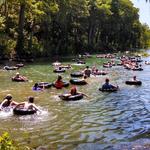
Smoky Mountain Tubing
Easy tubing down the river in Cherokee.
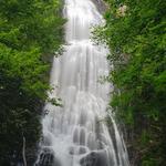
Mingo Falls
Mingo Falls is in the Qualla Boundary—a land trust of the Eastern Band of Cherokee Indians, just outside Great Smoky Mountains National Park. No special permits are required for access to the area. At 120 feet (36.6 m) tall, the waterfall is one of the tallest and most spectacular in the southern Appalachians. The hike to the waterfall is only 0.4 miles (0.6 km) in length, but is considered moderate in difficulty. Access Trail: Pigeon Creek Trail Trailhead: From Oconaluftee Visitor Center, drive south (toward Cherokee) on US-441 and take the second left onto Big Cove Road. At the first stop sign turn left and drive 4.5 miles (7.2 km) to Mingo Falls Campground, where the trail begins.
Bridal Veil Falls
Bridal Veil Falls is a 45-foot waterfall located in the Nantahala National Forest, northwest of Highlands, North Carolina. Bridal Veil Falls near Highlands has been famous for generations as the only waterfall in North Carolina you can drive behind. However, the section of road behind the falls is now blocked off from automobiles for safety. This allows you to walk behind and enjoy it more.
Grassy Creek Falls Trail- Bridal Veil Falls, Covered Bridge, High Falls and Triple Falls
Grassy Creek Falls is 1.3 miles along gravel road from the DuPont Forest Visitor Center. Along the way you will pass the covered bridge at the top of High Falls. Also links to Bridal Veil Falls, Covered Bridge, High Falls and Triple Falls.
Hooker Falls
12-foot waterfall with swimming hole.
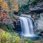
Looking Glass Falls
Looking Glass Falls is one of the most popular and beautiful waterfalls in North Carolina. And it's perhaps the easiest to view (one of the few accessible roadside waterfalls, making it perfect for folks with mobility and walking challenges). The name "Looking Glass" comes from Looking Glass Rock, where water freezes on its sides in the winter and then glistens in the sunlight like a mirror or looking glass. Looking Glass Creek, which flows past the rock, is also named for its impressive natural structure.
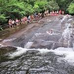
Sliding Rock-- Waterfall waterslide!
Sliding Rock is a 60 foot natural water slide that ends in a 8-10 foot deep pool of water, with 1 observation platform, operated by Naventure. The area is open 365 days a year, weather and water levels permitting. Lifeguards and restrooms are available seven days a week Memorial Day through Labor Day. When not staffed, there are no lifeguards and restrooms are closed. Sliding Rock is open 9:00am to 6:00pm, 7 days a week. Periodically, the parking lot fills up and will be closed until spaces become available. Plan to visit other nearby areas such as Looking Glass Falls or the Cradle of Forestry and come back to Sliding Rock later.
Graveyard Fields Upper Falls
Graveyard Fields is a very popular hiking trail on the Blue Ridge Parkway (Milepost 418.8) south of Asheville. The Yellowstone Prong is the water source for two waterfalls in a mile-high valley filled with wildflowers and surrounded by the 6,000-ft. peaks of the Blue Ridge Mountains. The area got its name years ago from the tree stumps that looked like grave stones in a graveyard setting. The trees were toppled by a huge wind several hundred years ago. Then in 1925, an intense fire burned the recently logged area, and the forest has been slow in recovering since. It's one of the few hiking places along the Parkway with restrooms! Take a short hike to a beautiful waterfall or a much-longer 3.5-mile loop through the meadow to a second waterfall.
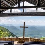
The Pretty Place
Camp Greenville welcomes visitors - at no charge - to enjoy the beauty of the Chapel during daylight, except when it is in use for a Camp event (Sunday and Monday morning worship services by campers or groups), or for another reserved event (weddings, dedications, memorial services, etc.). Typically the chapel is booked throughout the day on Saturdays and Sundays. We strongly recommend checking the online chapel schedule prior to visiting to avoid conflicts with weddings or other privately scheduled events at Pretty Place. Please note: there are NO restroom facilities available from December 1 - March 15.
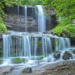
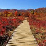
Brevard "Land of Waterfalls"
"Land of the Waterfalls" with over 250 waterfalls you can spend the day waterfall hunting.
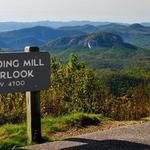
Pounding Mill Overlook
Pounding Mill is one of the most spectacular overlooks on the Blue Ridge Parkway. Located approximately 1 hour south of Asheville at Milepost 413.2, it is on the east side of the road and has long range views in three directions. On clear days, looking to the left you can see the Frying Pan Fire Tower and the Pisgah Inn as well as the thin ribbon of the Parkway road as it winds its way north. To the south, the towering Looking Glass Rock is hard to miss with its massive rock face serving as the most prominent landmark in the area. And straight ahead are the unobstructed views of layered mountains that no visit to the Blue Ridge Parkway is complete without. This part of the Parkway is surrounded by Pisgah National Forest, which provides a buffer of undeveloped forest and an expanse of luscious green that spreads out for miles. The overlook’s unusual name comes from hammer style mills that were built along mountain streams to grind corn.
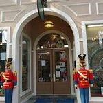
O P Taylor's
Top 10 toy store in the Country. 3 stories worth of toys. "The original store, located in beautiful downtown Brevard, North Carolina, is over 6,000 square feet of fun and hands-on excitement. There is a reason that O.P. Taylor’s continues to be the #1 toy store in the south, so come and experience it for yourself! All of O.P. Taylor’s stores are strategically located near terrific restaurants and other fascinating stores.

Mount Mitchell State Park
Mount Mitchell is the highest peak in the Appalachian Mountains and the highest point in mainland North America east of the Mississippi River. It's located in the Black Mountain subrange of the Appalachians, near Burnsville in Yancey County, North Carolina, about 19 miles northeast of Asheville. The mountain is 6,684 feet tall and is part of the Blue Ridge Mountains.

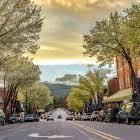
Asheville
Asheville- Home of the Biltmore Estate. Plenty of places to view art, eat, and explore.

Biltmore Estate
Biltmore Estate is a day adventure in itself. Gardens, food, wine, history, hiking and much more.