IRINA & MARIAN
Things To Do
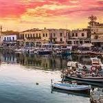
Venetian Harbour
The old (Venetian) harbour of Rethymno, which also lies in the heart of the harbour facilities, features: Total pier length 390 metres Sailing depth -2.50 metres Harbour land surface area 5,250 m2 Mainly fishing boats and yachts dock here. The Egyptian lighthouse overlooks the entrance to the harbour. The fishing boats and the yachts dock alongside the Venetian harbour where fish- restaurants are open during the summer months.
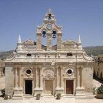
Monastery of Arkadi
The Arkadi Monastery is an Eastern Orthodox monastery, situated on a fertile plateau 23 km (14 mi) to the southeast of Rethymnon on the island of Crete in Greece. The current catholicon (church) dates back to the 16th century and is marked by the influence of the Renaissance. This influence is visible in the architecture, which mixes both Roman and baroque elements. As early as the 16th century, the monastery was a place for science and art and had a school and a rich library. The monastery played an active role in the Cretan resistance of Ottoman rule during the Cretan revolt of 1866. 943 Greeks, mostly women, and children sought refuge in the monastery. After three days of battle and under orders from the hegumen of the monastery, the Cretans blew up barrels of gunpowder, choosing to sacrifice themselves rather than surrender. The 8th of November is the day of national celebration in Rethymno.
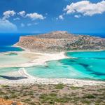
Balos Beach
Discover the westernmost tip of Crete on a scenic bus and boat trip to Gramvousa Island and Balos Bay. Dip your toes in the soft white sand of some of the most beautiful beaches you ever have seen!
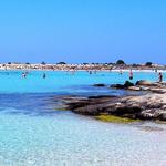
Elafonissi Beach
By far one of the most beautiful beaches on the island, Elafonissi is situated on the south west coast. A tropical effect is created by its white and pink coral sands. Head to the right for shallow water in a small enclosed lagoon ideal for the children. A walk through the lagoon to the islet is most worthwhile as you will discover this unique coastline. The coral sands and warm shallow waters attract swimmers, spearfishermen, and windsurfers from the world over.
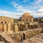
Fortezza Castle
The Fortezza (Greek: Φορτέτζα, from Italian for "fortress") is the citadel of the city of Rethymno in Crete, Greece. It was built by the Venetians in the 16th century, and was captured by the Ottomans in 1646. By the early 20th century, many houses were built within the citadel. These were demolished after World War II, leaving only a few historic buildings within the Fortezza. Today, the citadel is in good condition and is open to the public.
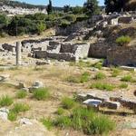
Eleutherna Archaeological Museum
Ancient Eleftherna is located in a distance of approx. 30 km. to the South East of Rethymnon and occupies two long, narrow ridges, called Pyrgi and Nissi. Three streams flow around the foot of the hills and join to the north of them. The urban center of ancient Eleytherna was always located at Pyrgi. Ruins of Hellenistic walls and buildings, Roman structures and an Early Christian basilica are preserved on the east slope of the hill. On the west slope of the hill, at the site called Orthi Petra (standing stone), lies the cemetery of the Late Geometric and Archaic periods, part of which was covered by the Roman buildings. Remains of a settlement that flourished in the Hellenistic period have been uncovered on the Nissi hill.
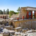
Knossos
Knossos is the largest Bronze Age archaeological site on Crete and has been called Europe's oldest city. Settled as early as the Neolithic period, the name Knossos survives from ancient Greek references to the major city of Crete. The palace of Knossos eventually became the ceremonial and political center of the Minoan civilization and culture. The palace was abandoned at some unknown time at the end of the Late Bronze Age, c. 1,380–1,100 BC.[4] The reason why is unknown, but one of the many disasters that befell the palace is generally put forward. In the First Palace Period (around 2,000 BC), the urban area reached a size of as many as 18,000 people. In its peak, the palace and surrounding city boasted a population of 100,000 people shortly after 1,700 BC.
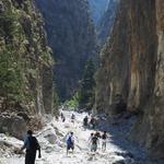
Samaria Gorge
Walking this ravine the real way, from the Omalos Plateau is something that will stay with you for a lifetime. The 16-kilometer hike begins at a viewing platform at the bottom of a circuitous path and wooden steps, where you’ll be bowled off your feet by the walls of rock that climb to almost 300 meters. On the way, the ravine will narrow to a stretch named the “Gates” or “Iron Gates”, where the gorge tapers to just four meters across. Look up as you walk, to catch sight of the endangered kri-kri, a kind of feral goat that makes light work of even sheer rock faces. At the end of the gorge, it’s another three kilometers to the coastal village of Agia Roumeli, where you can catch the ferry to Sougia in the west of Sfakia in the east.
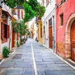
Old Town
The third-largest city in Crete also has what may be the best-preserved old town on the island. Originally behind walls, the city’s tight cobblestone alleys were laid out in the 14th century when Crete was in the hands of the Republic of Venice and has held onto its Renaissance mansions, arches, and catholic churches. If one building can sum up Rethymno’s tumultuous history it’s the Neratze Mosque. This started life as a Venetian Church, before becoming a mosque for almost 300 years up to 1925. Now it’s Rethymno’s municipal odeon, staging regular music concerts. Venetian monuments surviving in Rethymno include the 17th-century Loggia (also converted into a mosque by the Ottomans) and the Rimondi Fountain from 1629, framed by two pairs of Corinthian columns next to a Gothic arch.
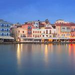
Old Venetian Harbour.
The Venetians started building Chania’s glorious harbor in 1320 and work would continue for the next three centuries. From the eastern end, there’s a mole, several hundred meters in length, leading to the lighthouse, a symbol for the city. This was built at the turn of the 17th century and got its minaret-like form in the Egyptian period in the 1830s. The western part of the harbor was where goods were brought ashore, while the more sheltered eastern pocket was for shipbuilding and maintenance.

Dive2gether Crete - 5 star PADI Diving School and Center
It doesn't matter what weather it is, you can always find a protected bay where you can enjoy a perfect day under the sea.
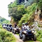
Discovery Quad-Buggy-Jeep Safari
GET OFF THE BEACH FOR A DAY AND EXPLORE THE REAL CRETE WITH DISCOVERY SAFARIS
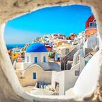
SeaJets Crete, Heraklion Port Desk & Santorini Cruise
Enjoy a day trip to Santorini either by Rethymno or Chania or Heraklion

Chania Wine Tours
Chania Wine Tours is the best way to swirl, sip, and taste your way through Crete. The only tour in Greece owned and operated by a Certified Sommelier.