Things To Do
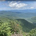
Slide Mountain
This is a 5.3-mile out-and-back trail near Big Indian, New York. Generally considered a challenging route, it takes an average of 3 h 24 min to complete. This is a very popular area for hiking and snowshoeing, so you'll likely encounter other people while exploring. Slide Mountain is the highest point in the Catskills and hikers will find a monument at the summit. Begin off Oliverea-Slide Mountain Road and cross over the West Branch of the Neversink River on the Phoenicia-East Branch Trail. Turn onto the Wittenberg-Cornell-Slide Trail to the summit of Slide Mountain.
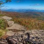
Giant Ledge Trailhead
Lost Cove Trail
Lost Clove is a lesser visited trailhead, in part due to more popular hikes farther up the valley. But this is also a difficult walk – 1.3 miles uphill, and much of it on a cobbly jeep trail. The trail ends at the blue-blazed Pine Hill West Branch Trail, which is a 14-mile ridge trail connecting five summits between Pine Hill and the West Branch of the Neverskink. From the junction of the Lost Clove and PHWB Trails, the summit of Belleayre Mountain (3375’) is another .85 mile, with the Belleayre Lean-to along the way. Heading in the other direction (north) from the junction, the hamlet of Pine Hill is reached in about two miles after walking down the mountain.

Fruition Chocolate Works
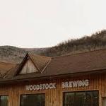
Woodstock Brewing

West Kill Brewing

Hanah Mountain Resort & Country Club
18 hole golf course

Woodstock, NY